
"When you try to change a single thing, you find it hitched to everything
else in the universe..."
John Muir
Welcome
Click on the pictures for more information...

Training Guidelines
AQUATIC
SECTION

FORESTRY
SECTION

SOIL
SECTION

WILDLIFE
SECTION

SPECIAL
TOPIC SECTION

FORESTRY SECTION
FOREST EVALUATION STUDY GUIDE
Every acre of land should be devoted to its best use. This is an idea that landowners have had about agricultural land for many years. Level and slightly rolling land was used for row crops and grain, and rolling and better upland slopes for pasture and meadow. The general ideas about forest land is that forests will grow well on all lands not suited for other crops. This is not correct. There are excellent, good, fair, and poor sites for timber production just as there are different kinds of farm crop land. There are forest lands that will economically support cultural practices and permanent physical improvements, and other stands in the same area might barely pay land taxes. There are acres that can be harvested every 10 years, and there are other acres that may never produce commercial timber. Forest Evaluation is based on the premise that trees will be harvested, now orin the future, to maximize the goals of a specified landowner.
SITE EVALUATION
The site is the habitat or environment in which a plant or plant community lives. There are a number of site factors that determine the desirability of a particular location for tree species. Some of the factors are soil depth, slope percent, aspect and slope position. These factors can be used to determine the forest land capability class of a particular tract of land.
Soil depth is the distance from the soil surface down to unweathered rock or an impermeable layer which restricts water movement and root penetration. For contest purposes shallow soils are less than 24 inches deep, and deep soils are greater than 24 inches deep.
Slope percent is the number of feet of rise or fall in 100 feet of horizontal distance. For contest purposes slope percent is broken into the following categories: 0-20 percent, 20-40 percent and 40 percent plus. Slope percent can be measured with an Abney level or a clinometer.
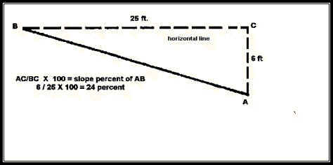
Method of determining slope percent.
Aspect is determined by taking a compass reading while facing down
a slope. The direction water would run gives the compass direction. Any slope facing north
and east of a line extending from northwest to southeast is considered to have a desirable
northeast aspect. Any slope facing south and west of the same line is considered to have a
less desirable southwest aspect.
Method of determining aspect.
Slope
position is determined only on hilly sites. The positions are classified
as upper 1/3, middle 1/3 and lower 1/3. Ridge tops or level plateaus and bottomlands are
classified separately in land capability.
Forest
land capability classes are described below for the purpose of this
contest:
Class I.
Excellent has few limitations for tree growth. Most sites have little slope and no
erosion problems. The soil is fertile and holds water well. It is well drained, but not
droughty.
These site will produce timber
well.
Class II.
Good is usually gently sloping. In some cases there are drainage problems that
affect tree growth.
Class III.
Fair may be fairly steep. Soils may have low fertility and tend to be droughty.
Class IV.
Poor may be very steep with shallow soil. Sites may be rocky, shaly, have low
fertility and be very dry.
FOREST STAND
EVALUATION
Grazing
damage is defined by the following categories for the purpose of this
contest:
Grazed
- tree seedlings eaten or trampled, soil compacted, and bark rubbed off,
and
Ungrazed
- no evidence of grazing damage.
Fire
may be present as a destructive agent or a management tool.
Wildfire
can be very destructive particularly in hardwood forests. Destruction of the litter
layer on the forest floor, crown scorch or burning of the foliage, and scalds or scars on
the tree trunks are all evidence of wildfire damage.
A
Prescribed
fire or controlled burn is a forest management tool which can be used to
manage competing vegetation, prevent fuel accumulation, and improve wildlife habitat
without damaging the crop trees.
Size
distribution is classified into 4 categories for the purpose of this
contest. In all-aged stands there may be 2 or more size classes represented. In many
even-aged stands there will be only one size class. Specific size classes are defined as
follows: 0-1 inch DBH - reproduction, 1-3 inches DBH - saplings, 3-12 inches DBH - poles,
and more than 12 inches DBH - sawtimber.
Forest
types are different from each other in species composition and management
requirements. The following forest types,
defined by the Society of American Foresters in Forest
Cover Types of North America, are used in this contest:
Pine
(Type 75, Shortleaf Pine; Type 80, Loblolly Pine–Shortleaf Pine; and Type 81,
Loblolly Pine)
Pine-Hardwood
(Type 76, Shortleaf Pine–Oak; and Type 82, Loblolly Pine– Hardwood )
Upland
Hardwood (Type 52, Red Oak–White Oak–Hickory)
Bottomland
Hardwood (Type 91, Swamp Chestnut Oak–Cherrybark Oak;
Type 92, Sweetgum–Nuttall Oak–Willow Oak)
Stand
origin can vary from one stand to another, even though the stands are of
the same forest type and size distribution. Timber stands may originate by several
different means. Natural stands may arise from
seedlings,
sprouts or a mixture. Sprout or coppice forests can become unhealthy because
disease and decay organisms are sometimes transmitted from the parent trees to the sprouts
through the root systems. Stands which originate from planted seedlings are called
plantations.
Stocking
is a term used to describe how well the trees in a stand utilize the available
space.
Stocking, for the purposes of this
contest, is measured using the average diameter of all trees 10 inches dbh and larger, and
the number of trees per acre 10 inches dbh and larger.
A
well-stocked
stand
is one in which the trees are well distributed, and all the space is utilized, but the
trees still have room to grow. An
understocked
stand
is one in which there are open spaces between the trees so that the stand will not produce
its full potential. An
overstocked
stand
is one which is so crowded that trees are growing very slowly, and some may be dying
because of too much competition.
For example:
If
the plot size is 1/10 acre, average dbh of trees 10 inches dbh and larger is 16 inches and
the number of trees in the plot 10 inches dbh and larger is 12, is the stand understocked,
wellstocked, or overstocked? If there are 12 trees in a 1/10 acre plot there are 120 trees
per acre. Method
of determining stocking
FOREST
INVENTORY
Species of
each numbered tree should be listed using the common names from the Official Tree List.
Crown
class of each tree should be determined and recorded as either dominant,
co-dominant, intermediate, or suppressed. These crown classes are defined in the Glossary DBH(diameter
at breast height) of each tree should be measured and recorded in even-numbered, 2-inch
diameter classes. The smallest diameter class is 10 inches.
Height
in 16-foot logs of each tree should be measured and recorded to the nearest full
half-log. The shortest height is 1 log.
Board-foot
volume per acre – The board-foot volume of each tree should be
determined and recorded . Then, after taking into account the plot size, the
board-footvolume per acre should be calculated.
Tree
value per acre – The dollar value of each tree should be determined
by multiplying the volume of each tree, expressed in thousand board feet, by the value of
that species per thousand board feet.
RECOMMENDED
PRACTICES
A list of
forest management practices appears on the Forest Evaluation Score Sheet. Each team will
be given
a
written scenario with information about the landowner and his or her objectives for
management. Based on the data you collected about the site and forest stand, and on the
landowner's management objectives, consider each practice listed on the score sheet. Mark
the practices you recommend. The practices recommended should be those which will improve
the stand and help accomplish the landowner's objectives.
Sample
Scenario – Mr. Ken Smith, who lives in Washington DC, bought this 200
acre tract of property in western Pulaski County, Arkansas as an investment. No timber has
been harvested here in more than 30 years, so the timber is financially mature. A
consultant, Mr. Bill McKee, has recommended that Mr. Smith encourage natural shortleaf
pine regeneration on this site by using the seedtree system. Mr. Smith wants you to help
him figure out how to accomplish Mr. McKee’s recommendations. He realizes that it may
be necessary to control undesirable species in 5 to 10 years and that smoke management may
be a problem because it is so close to an urban area. You may beinterested in the
following information. The marked plot is 1/10 acre in size. The timber in the plot is
representative of the entire 200 acres. The slope on the plot falls 15 feet in 100 feet of
horizontal distance. The soil is 18 to 22 inches deep and has a fine sandy loam texture.
Pine sawtimber is currently selling for $350 per thousand board feet, while Oak sawtimber
is selling for $250 per thousand board feet.
Thinnings
- are partial cuttings in even-aged timber stands. They are designed to improve
future growth by regulating stand density. Thinnings can be commercial, where some or all
of the wood harvested is put to use, or precommercial, where no wood is utilized.
Salvage
or Sanitation Harvests - are cuttings by which the dead, dying, damaged,
ordeteriorating trees are removed to prevent the spread of pests as well as putting this
"at risk" wood to use.
Selection
Harvests - is a regeneration method in which individual trees or groups of
trees are removed to improve the stand and to provide space for new trees to become
established. By removing undesirable trees or species, poorly formed trees or mature trees
with this method, an uneven-aged stand structure results.
Shelterwood
or Seed Tree Harvests - are regeneration methods designed to create an
even-aged timber stand. These harvests remove the mature stand leaving only a few trees
per acre to provide seed or shelter in order to establish a new stand.
Clearcut
or Clearcutting - is a regeneration method that involves the removal of
the entire stand in one cutting to create an even-aged stand. Regeneration may be provided
for naturally, where a seed source from a desirable tree species exist, or artificially,
where planting or seeding of a desirable tree species is required.
Best
Management Practices (BMPs) - are a combination of practices, that are
determined by a state to be the most effective, practical means of preventing or reducing
the amount of pollution generated by nonpoint sources (such as managed forests) to a level
compatible with water quality goals. These practices are normally used during timber
harvesting and site preparation.
Prescribed
Burning - is generally used as a means of controlling hardwood vegetation
in pine stands. Prescribed burning also improves wildlife habitat, stimulates sprouting
seed germination, and encourages the growth of herbaceous plants.
Wildlife
Habitat Improvement - Wildlife will generally coexist with any forest
management scenario but the type of wildlife will vary depending on the management system
a forester employs.
Most wildlife species
prefer a varied landscape with many edge and riparian zones. The type of wildlife a
forester manages for is largely dependent on landowner objectives but also the type of
forest a particular site will support
Recreational
Opportunities - Recreation often goes hand-in-hand with forest management. Hiking, hunting, fishing, camping, ATV riding,
mountain biking and bird watching are only a few of the types of recreation for which a
forester might manage a forest. The ultimate decision should be largely based on the
objectives of the landowner.
Non-Timber
Forest Products - This area of forest management can work simultaneously
with other forest management practices and is more developed in some regions of the United
States such as the Pacific Northwest. It may be a hobby for some landowners yet can also
generate a significant cash income for other landowners. Such things as Ginseng, St.
John's Wort, and a whole host of mushroom species are items that a forester should be
aware of and could be managing for given proper site conditions. 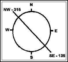
Dominant species – loblolly and/or shortleaf pines make up more than 50% of the
stand.
Associated species – post oak, southern red oak, black oak, white oak, northern red
oak, other oak species, sweetgum, blackgum and hickories.
Dominant species – loblolly and/or shortleaf pines make up 25 to 50% of the
stand, and are mixed with post oak, southern
red oak, black oak, white oak,
northern
red oak, and other oak species.
Associated species – sweetgum, blackgum and hickories.
Dominant species – white oak, northern red oak, black oak, southern red oak, other
oak species and hickories.
Associated species – blackgum, sweetgum and elms. Pines, where present, make up less
than 25% of the stand.
Dominant species – bottomland oaks (swamp chestnut oak, cherrybark oak,
Nuttall oak, willow oak, water oak, Shumard
oak, southern red oak, white oak) and sweetgum.
Associated species – blackgum, hackberry, green ash, red maple, elms and
hickories.
Pines, where present, make up less than 25% of the stand.
These stands may be of higher quality than their predecessors if genetically improved
seeds or seedlings are used.
Values for each species will be given in the written situation description. For example:
if a 20 inch, 2½ log white oak contains 348 board feet, and white oak sells for $300 per
thousand board feet, then the value of the tree equals $300 X 0.348 = $104.40. Then, after
taking into account the plot size, the tree value per acre should be calculated.
For additional information about the Envirothon Program in Arkansas, contact:
Delia Haak, Ed.D Arkansas Envirothon Coordinator
ArkansasEnvirothonCoodinator@gmail.com
479-238-4671
Debbie Moreland, Arkansas Association Conservation District Director
debbiepinreal@aol.com
501-425-2891
The Envirothon Program is offered and operated on a nondiscriminatory basis without regard to race, color, national origin, religion, sex, age, marital status, or physical/mental challenges.