
"When you try to change a single thing, you find it hitched to everything
else in the universe..."
John Muir
Welcome
Click on the pictures for more information...


Training Guidelines
AQUATIC
SECTION

FORESTRY
SECTION

SOIL
SECTION

WILDLIFE
SECTION

SPECIAL
TOPIC SECTION

FORESTRY SECTION
COMPASS TRAVERSE STUDY GUIDE
Foresters are often required to estimate horizontal distances by the pacing method, and to determine direction of travel by using a compass. These methods are very useful in cruising timber and finding property boundaries.
All maps and land surveys express the distance between two points as the horizontal distance, that is the distance measured on the level. Thus it becomes necessary to correct for slope when estimating horizontal distance to the ground. Pacing is an expedient, but crude, method of determining ground distances. A pace is two steps (Figure 1). On level, open ground, pacing can become fairly accurate with practice. But ono slopes, and in brushy or rocky areas, its accuracy dimishes (Figure 2). To correct for slope the folowing suggestions from the Forestry Handbook are provided:
In difficult terrain no attempt should be made to maintain a standard pace. Instead, allow for its inevitable shortening (downhill as well as uphill) by repeating the count at intervals. For example, on moderate slopes count every then pace twice: 1, 2, 3, 4, 5, 6, 7, 8, 9, 10, 11 etc. On steeper slopes it may be found necessary to repeat every fifth count: 1,2,3,4,5,6,etc. On the steepest slopes in very heavy brush, in swamps, or among boulders, every count may be to be repeated. Consistent accuracy in pacing under such condition is attained only by practice and is maintained only by constant checking. (Forestry Handbook, 1955. Page 17-1)
Remember, pacing is only an estimate that
will get you close. Accurate pacing
in difficult terrain whether steep or covered with obstacles takes years of
practice. For the purposes of the Envirothon
contest, a good understanding of your individual pace on rolling terrain will be
sufficient.
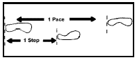
Figure 1. Illustration showing the difference between a step and a pace.
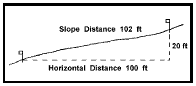
Figure 2. Estimating hotizontal distance on a 20% slope.
A compass is used to tell the direction of travel by estimating the angle of deflection from magnetic north. Magnetic north is the direction toward which the compass needle always points. Most compasses are designed to measure direction in either azimuths or bearings. Azimuths range from 0E to 360E (Figure 3), and bearings range from 0E to 90E in each of four quadrants (Figure 4).
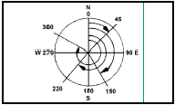
Figure 3. Azimuths are read from an azimuth compass.
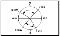
Figure 4. Bearings are read from a quadrant compass.
For additional information about the Envirothon Program in Arkansas, contact:
Delia Haak, Ed.D Arkansas Envirothon Coordinator
ArkansasEnvirothonCoodinator@gmail.com
479-238-4671
Debbie Moreland, Arkansas Association Conservation District Director
debbiepinreal@aol.com
501-425-2891
The Envirothon Program is offered and operated on a nondiscriminatory basis without regard to race, color, national origin, religion, sex, age, marital status, or physical/mental challenges.